9.15.23 ~ Bolin Creek Trail Chapel Hill, North Carolina
At last, walking weather arrived Friday morning! We decided to try Bolin Creek Trail. It was a pleasant enough walk, but it was paved, which is hard on Tim’s back and hip. He needs uneven terrain to walk at all comfortably. And there were many joggers out and lots of people. There were cars zooming by on the road on the other side of the creek. It didn’t feel at all like a walk in the woods!
a burl on a loblolly pine tree
Still, we were delighted to be out getting some fresh air and moving our bodies for an hour. I doubt this will become one of our favorite walks but it was nice to get more familiar with what we have for options in our vicinity.
Hurricane Florence must have been a doozy back in 2018. Apparently Bolin Creek floods quite frequently but I haven’t been able to find out how high it was during that storm. I was standing on stairs leading up to the road to get the next three pictures. The tunnel goes under another road.
Tim standing under the high water mark (see sign below)
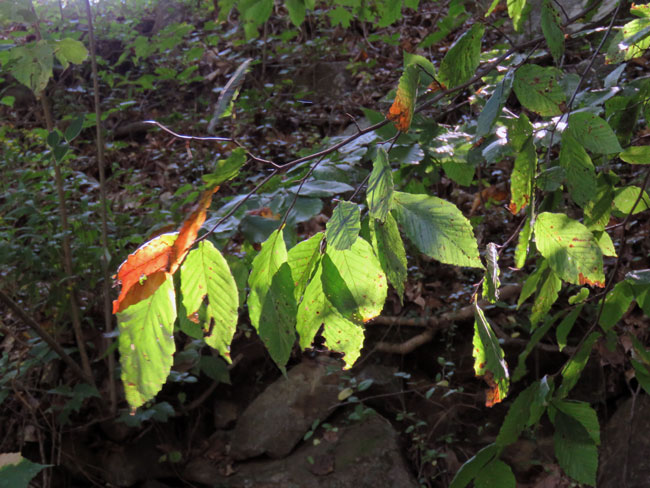
There were some interesting tree roots along the mostly shaded creek.
bits of sunshine poking through the leaves
playing hide and seek with this squirrel can you find him?
very tiny hemlock sapling trying to grow in the dark understory
Like Gold Park in Hillsborough that we visited a month ago, this trail had an urban feel to it. I think we’re going to have to venture farther from home to find some more woodsy walks to explore. I’m getting excited and hopeful about the possibilities.
3.22.22 ~ Rocky Neck State Park, East Lyme, Connecticut
There are still a few places to walk we haven’t visited yet so we decided to check another one off of our still-growing list. Rocky Neck State Park is a little farther west down the coastline than we usually like to go, but seeing pictures of birds taken there and posted online tempted me to give it a try. Sadly, no birds on this windy day. We had to walk through a tunnel (see above picture) under the Amtrak railroad to get to the beach.
This beach is one of the most visited beaches in Connecticut, with some of the buildings at the beach even dating back to the 1930s. This is one of the most popular beaches to visit for those in the area because of how scenic it is. ~ Roaming the USA website
The fact that it is so popular is probably another reason we never tried to come here before. Every summer weekend morning on the news we hear that the parking lot is full and no more cars are being allowed in. When traveling down the interstate we often see flashing LED changeable message signs, miles in advance, announcing the same thing.
We walked down the beach and up a ledge, following a sign saying “Pavilion.” The pavilion was huge! (Perhaps built in the 1930s?) We followed a tunnel through the bottom of it and took some stairs up the back, then came around to the front and took some pictures of Long Island Sound.
tunnel under the pavilion
pavilion balcony on top of ledge
Long Island Sound from the pavilion balcony
Behind the pavilion was a pedestrian bridge (above) back over the Amtrak railroad tracks. We decided to go for it, lured in by a point on a map of the park called Toby’s Nose Overlook. Eventually we found the spot but the viewing platform I was expecting did not exist. There was a complicated maze of trails, parking lots and driveways in the woods back there, but we finally figured out a zig-zaggy route we could take back to the car.
view of Four Mile River from Toby’s Nose Overlook
a glimpse of Long Island Sound through the woods
glacial erratic on top of a hill
When I got home and studied the map a little more closely I noticed that there was another part of the park, along Bride Brook, with a crabbing deck and an actual viewing platform. Maybe next time. Turns out we had only seen a very small portion of this place.
And now to prepare for a visit from our daughter and granddaughter! Kat has spring vacation so Larisa is going to work remotely here while we have Kat to ourselves for half the week. 😊 (Kat’s other grandparents will have her the first half of the week!)
3.26.22 ~ Look who are coming for a visit!!! (Larisa & Kat)
1.19.21 ~ Fort Griswold Battlefield State Park Groton, Connecticut
Near the end of December we found the graves of a couple of Revolutionary War soldiers on a walk in Stoddard Hill State Park. Debbie, one of my readers, mentioned that they don’t have graves that old where she lives in Illinois. So, although I much prefer nature walks, I decided we could change things up a bit and take a history walk. Because of Debbie’s comment I have a new appreciation for the historic Battle of Groton Heights that took place right here in my town. (Link is for history buffs.)
DEFENDERS OF FORT GRISWOLD • SEPT • 6th 1781•
This is the historic site where, on September 6, 1781, British Forces, commanded by the infamous Benedict Arnold, captured the Fort and massacred 88 of the 165 defenders stationed there. The Ebenezer Avery House which sheltered the wounded after the battle has been restored on the grounds. A Revolutionary War museum also depicts the era. Fort Griswold was designated as a state park in 1953. ~ Fort Griswold Battlefield State Park website
Col. Ledyard memorial
There is some doubt about the details of this story. The shirt and vest Col. Ledyard was wearing when he was killed had tears in the side, suggesting a bayonet wound is what caused his death, not his own sword in the hands of a British officer.
parade ground in the fort
dried seed pods on the wall
Critical acumen is exerted in vain to uncover the past; the past cannot be presented; we cannot know what we are not. But one veil hangs over past, present, and future, and it is the province of the historian to find out, not what was, but what is. Where a battle has been fought, you will find nothing but the bones of men and beasts; where a battle is being fought, there are hearts beating. ~ Henry David Thoreau (A Week on the Concord & Merrimack Rivers)
dried seed pods on the wall
a door in the fort wall
looking down at the lower battery, seen from the new viewing platform
USCGC Eagle docked across the Thames River at Fort Trumbull in New London
The 295-foot Barque Eagle is the flagship of the U.S. Coast Guard. She serves as a training vessel for cadets at the Coast Guard Academy and candidates from the Officer Candidate School. The Eagle is the only active-duty sailing vessel in America’s military, and one of only two commissioned sailing vessels, along with the USS Constitution. ~ US Coast Guard Academy website
Tim at entrance to the tunnel through the wall of the fort
Tim at exit of the tunnel through the wall of the fort
From the tunnel we followed a trench down the hill. The trench hid the soldiers from enemy fire as they moved between the fort and the lower battery.
view from the trench
looking down the trench, it turns to the left ahead
after the turn, getting closer to the end
powder magazine, built in 1843
looking up at the fort, the trench zig zags to the right
Off to the side on the lower battery is the restored Ebenezer Avery house. It was moved to this location from a nearby street in 1971.
In the old times, women did not get their lives written, though I don’t doubt many of them were much better worth writing than the men’s. ~ Harriet Beecher Stowe (The Pearl of Orr’s Island: A Story of the Coast of Maine)
Anna Warner Bailey
Sometimes I think that historical houses should be named after the wives and daughters who lived in them, to honor them, as they very likely spent more time working there than the men who were out and about in the world.
But on a plaque outside this house I found a picture of Anna Warner Bailey (1758-1851) and the note that she was one of the first women to tend to the wounded after the battle. When I got home I found this online: Our Petticoat Heroine by Carol Kimball
We’ll have to wait until the pandemic is over before we can tour the house. I discovered a bit of synchronicity, we happened to be visiting this place on the 170th anniversary of Anna Warner “Mother” Bailey’s death. And there is a house named for her close by, where she had lived.
entrance gate and Groton Monument, seen from lower battery
The Groton Monument was built between 1826 and 1830, and is the oldest monument of its type in the country. Built of granite quarried locally, the Monument stands 135 feet tall with 166 steps. ~ Fort Griswold Battlefield website
We will also have to wait until the pandemic is over before we can tour the monument and small museum.
When I was preparing this post I noticed I already had a category for Fort Griswold Battlefield State Park. With another nod to synchronicity, it turns out Tim & I visited the fort nine years ago, almost to the day! The trench looks a little different nine years later. We had climbed up on the fort wall, which is no longer allowed. They have installed a viewing platform on the wall sometime in the past nine years. My, how things keep changing… The views of the river and city below are amazing. My old post: Fort Griswold Battlefield
Morning light in Flåm, Norway, looking off the balcony of our hotel room. (above) Morning is my favorite time of day and this particular morning we did not have to rush off to catch a train or a ferry or a bus so we could enjoy a a few leisurely hours in the village before our next adventure.
good morning! ~ friendly little curious female house sparrow
later on we would cross this bridge on a bus to get to a long tunnel to Gudvangen
it didn’t take me long to find a few gulls
entrance to Ægir Brewery & Pub, where we had dinner the night before
wood carvings in a dead tree near our hotel
so many lovely birch trees
Ægir Brewery & Pub ~ it’s only open for dinner
Flåmsbrygga Hotel, the warmth of knotty pine floors and doors
Ægir Brewery, sign above entrance
Tim on a little stone seat sticking out of the wall of the Flåmstova Restaurant
wall in the Flåmstova Restaurant, where we had breakfast
ceiling in the Flåmstova Restaurant
While we were eating breakfast by a picture window, enjoying the view of garden, fjord and mountain, a cruise ship very slowly pulled into port! Then we could barely see the mountain over the top of it! Cruise ships are amazingly large – Flåm was such a tiny port I am sure it couldn’t possibly accommodate more than one of them at a time.
I still can’t get over how it was spring on the fjord and winter in the mountains
there was a hiking path up through the farms hugging the side of the mountain
wish we had time to hike up there, but the zoom lens came in handy to capture this scene
We boarded a small bus to take us through the mountains to Gudvangen. This is the entrance to Flenja Tunnel (above) which is 5,053m long. (16,578′). We came out of it for only 500m (1,640′) before entering Gudvanga Tunnel, which is 11,428m (7.1 mi) long, Norway’s second longest road tunnel.
Next stop: Ferry ride on Nærøyfjord from Gudvangen back to Flåm.
Brevik is the place in Norway I most wanted to see. My grandmother’s sea-captain great-grandfather, Ingebrigt Martinus Hansen, was born there in 1818 and emigrated to America by himself in 1836. As far as I can tell, his parents, five brothers and two sisters remained in Norway. Was he a rebellious teen? Or simply restless, adventurous? His grandfather was a ship’s carpenter, his father and four uncles, all sailors. According to Wikipedia, Brevik is thought to be one of the best preserved towns from the sailing ship era.
5.21.15 ~ Brevik, Norway
Brevik is now part of Porsgrunn in the county of Telemark. The Brevik Bridge (Breviksbrua) in the background (above) goes over the mouth of Frierfjord to Stathelle, which is part of Bamble. It was opened in 1962.
5.21.15 ~ Brevik, Norway
We arrived in the evening, much later than planned because our plane was delayed and it took forever to pick up the rental car. But the two-hour ride from Oslo was beautiful, the scenery lovely. Because the sun sets so late we were still able to stop for dinner and explore the town afterwards.
5.21.15 ~ Brevik, Norway
The restaurant we found was Sjøloftet (above). Brevik isn’t a tourist destination per se, but we found that our server spoke English and was even able to find and dust off 4 menus translated into English. The place was naturally full of talkative locals and it was nice to just sit back and absorb the sound of the language and imagine, while looking out the window over the water, what life was like here 200 years ago.
5.21.15 ~ Brevik, Norway
The roads going up and down the sides of the fjord in town were very steep!
5.21.15 ~ Brevik, Norway
There were sailboats and motorboats tucked into every possible mooring.
5.21.15 ~ Brevik, Norway
A switchback road can be seen to the left of and behind this building.
5.21.15 ~ Brevik, Norway
Sleepy little seaside village…
5.21.15 ~ Brevik, Norway
The asymmetrical Grenland Bridge (Grenlandsbrua) (above) is new, opened in 1996. According to Wikipedia, it “is Norway’s highest cable-stayed bridge with a tower height of 168 metres (551 ft) … when built, it replaced Brevik Bridge as the primary route across the fjord … the 608-metre (1,995 ft) long bridge uses cable stayed construction to provide clearance for vessels up to 50 metres (164 ft) in height.”
Inadvertently we wound up going across the bridge! We were going through a tunnel and it came out right onto the bridge! I suppose it was inevitable as we were exploring the higher elevations of the town. But we made a u-turn and crossed back to Brevik. We actually got pretty confused exploring the town. Some of the streets were very steep and had surprise dead-ends!
5.21.15 ~ Brevik, Norway
This little part of town is tucked under the older Brevik Bridge.
5.21.15 ~ Brevik, Norway
One of the dead-ends we came upon. It was fun (and a little embarrassing) having to do a 20-point turn with the rental car to back out of there…
5.21.15 ~ Brevik, Norway
When we found the correct tunnel to leave Brevik we had to wait and then follow a leader car through it because only one lane was open. We didn’t see any flagmen in Norway where there was roadwork being done. Everyone just waited patiently until the leader car was done leading the opposing line of traffic through and then turned around and signaled for them to follow.
Satisfied to have seen the place where my ancestor started his journey, we headed for Skien to spend our first night in Norway.
So far this winter has given us only very cold days alternating with unseasonably warm days. Without a blanket of snow, everything looks barren and oddly exposed. Last January was the snowiest month ever in Connecticut history and it made for some very nice pictures! But now that we have a new camera there is no inspiration to get out there and put it to good use, but we decided to give it a try anyway.
Close to home is Fort Griswold Battlefield State Park. War is not my favorite subject, but this is the site where, on September 6, 1781, the traitor and Connecticut native Benedict Arnold led the British on a raid during the Revolutionary War. About 150 colonial militia and local men under the command of Col. William Ledyard were outnumbered. The British demanded surrender but Ledyard refused at first. There were heavy losses on both sides. The last picture tells how it ended.
The first picture was taken outside the dirt and stone wall surrounding the top of Fort Griswold. The second picture is Tim standing in a trench leading up to the top of the fort. The picture above is the entrance to a tunnel leading in to the highest part of the fort, and the picture below was taken inside the tunnel.
Through the tunnel now, in the picture below we are standing inside of the stone and dirt wall, which is taller than us, looking toward the Thames River and New London.
In the next picture we have climbed up the wall and are looking down at the Thames River and New London on the other side. British troops had set most of New London on fire, and from here the men from Groton must have seen all the fires burning and the British ships in the river…
It was a gruesome battle — aren’t they all? The British made it to the top in spite of many casualties… It’s sobering considering what happened here.
I took all these pictures with my gloves on — it was cold! — and I can’t remember which settings I was using on which shot. Clearly I am going to have to wait until spring to practice with the camera outside. Will have to see what I can learn about using it inside while I’m waiting for warmer weather!
Groton is also home to Haley Farm State Park. Last year in February Beverly and I took a long walk here, too. This winter I have not been as interested in getting outdoors, but it’s nice to remember when I had a bit more energy, and blog about last year. Above is a lovely view of Palmer Cove from Haley Farm.
backside of Canopy Rock
The backside of Canopy Rock, above. It seems to be a place for kids to hang out and leave artwork. We didn’t see any litter, which was thoughtful of them.
side view of Canopy Rock
In the above side view picture the “canopy” part of the rock is clear. In the distance is the Amtrak railroad elevation. In the picture below is a tunnel under the railroad tracks, originally used for livestock – it must have been small livestock – clearance is only 4 feet! Can’t imagine a cow crawling under there!
livestock tunnel under the railroad tracks
If one doesn’t mind crawling through, our map tells us that on the other end of this tunnel are paths connecting to the trails in Bluff Point State Park. We didn’t attempt it, curious or not, we’re not engineers but we wouldn’t want to be under there if a train should zoom by overhead. A little close for comfort, too. At least we could see the light at the end of the tunnel. But, still… If we turned around now, we could see Race Track Pond, or actually the reeds surrounding it.
Race Track Pond, obscured by reeds
We decided to follow a deer trail, figuring they would know the easiest way through the reeds to find the pond for a drink of water.
reeds surrounding Race Track Pond
We did find a spot where the ice had been broken through and guessed that might be where the deer would find their water.
I please myself with the graces of the winter scenery, and believe that we are as much touched by it as by the genial influences of summer. ~ Ralph Waldo Emerson (Nature)
snow covered ice on Race Track Pond
It was beautiful with the long winter shadows of the reeds on the snow-covered ice. We didn’t know it then, but we were to be inexplicably unable to retrace our steps. Lost!
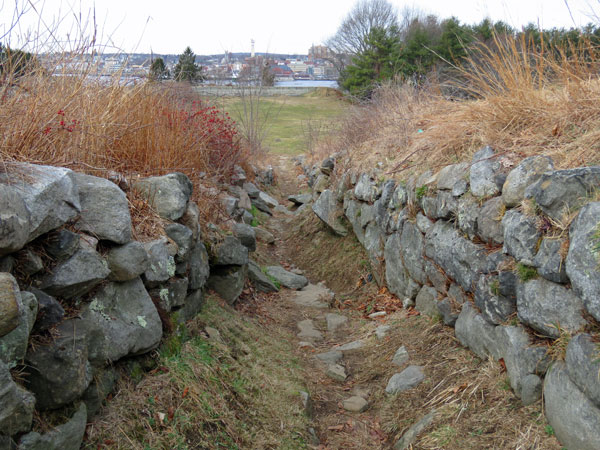
When a man named Caleb Haley owned the farm he built a lot of stone walls around his pastures, using an ox drawn stone-puller. I meant to photograph some of them on our way out, but, we were very cold and had very likely been walking around in circles trying to figure out a badly drawn map. When we finally saw the entrance (exit!) I quickened my step and fell on an icy spot of snow. Wrenched my shoulder so badly it still hurts a little even now, a year later.
So perhaps this year, maybe in the spring, I’ll return and try to get some stone wall pictures!