On the last Saturday in April we took a nice walk through the woods at the Woodlot Sanctuary. It was the first time in the spring that we needed bug spray! We loved all the stone walls.
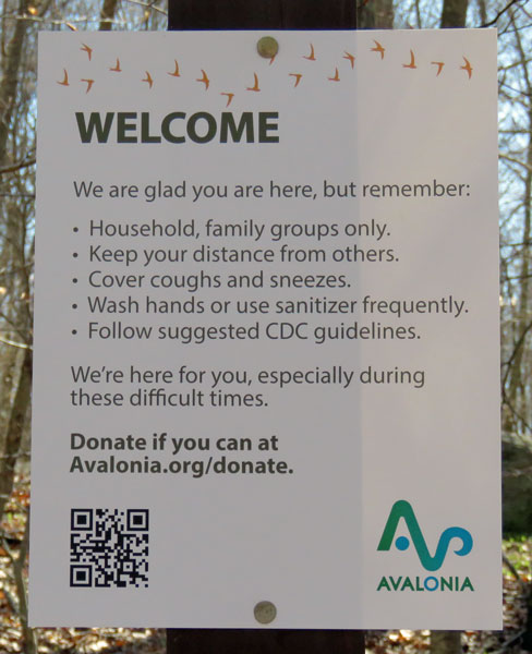
4.25.20 ~ sign of the times
Three lots totaling approximately 29 acres include a variety of habitats. Much of the central portion is upland forest featuring rocky outcrops and glacial erratics. The landscape shows a history of varied forestry practices over decades. It is now dominated by oak and beech with hickory, sassafras, and scattered evergreens as well, and offers an excellent understory of huckleberry and lowbush blueberry. The eastern border is comprised of wetlands that emerge into a brook that flows ultimately into Stonington Harbor; wetlands in the western portion drain directly into the Deans Mill Reservoir. The preserve is home to a variety of wildlife including several species which have special status in CT. Box turtles and spotted turtles have been found on the property. Red-shouldered hawks and broad-winged hawks are regular nesters as well. ~ Avalonia Land Conservancy website
4.25.20 ~ an inviting turn on the path
When we spotted the huge boulder below I was so surprised by what I found behind it. A hemlock tree! There aren’t too many of these beloved trees left in Connecticut because of the woolly adelgid infestation. You can imagine I spent a lot of time communing with this one.
hemlock tree trunk
It’s not easy to get to the lower branches. I remember getting a chair or a stepladder to help me get to the bottom branches so I could climb my tree.
underside of lower branches
looking up
For a child, the branches are nice and close together, making the climb feel pretty safe. I don’t think I could fit between those branches as an adult! After I grew up my mother told me that she couldn’t keep watching if she looked out the window and saw me climbing my favorite hemlock tree. But she never stopped me.
the bark
How do parents feel about children climbing trees these days? There are so many safety rules, like wearing bike helmets or harnesses in high chairs, that we never had when I was a child.
what a beauty
I would have loved to climb this hemlock! But it was so pleasant spending some time with it and touching it and appreciating its being. I hope it’s okay. I wonder how it survived. When you think of it, trees have suffered from their own pandemics over time. The deaths of my childhood hemlocks were very prolonged and painful for me to witness.
one of many stone walls
4.25.20 ~ princess pine poking through the leaves
We now have 86 confirmed cases of COVID-19 in our town. Our county (New London) has 623 confirmed cases and 43 deaths. Still rising. But, I’m starting to feel a little bit of hope.
There’s a chance that hundreds of millions of doses of a potential COVID-19 vaccine could be available by early next year, Dr. Anthony Fauci, a key member of the White House coronavirus task force, said Thursday, even though the federal government has not approved a vaccine against the virus. ~ Brakkton Booker (National Public Radio, April 30, 2020)
On Friday we tried the new-to-us park again and this time there was noone in sight at the trailhead – yay! This property was acquired in 2013. After crossing a little bridge over a brook we climbed up to Candlewood Ridge and enjoyed looking up and down the ravine on the other side. We followed the trails for over an hour. Tim’s legs and back did much better and I’m wondering if walking on the earth is better for him than walking on hard surfaces like pavement and concrete.
4.17.20 ~ crossing a stream, skunk cabbage
Candlewood Ridge is part of a critical large block of diverse wildlife habitats highlighted on the State of CT Natural Diversity Database maps: early successional forest, oak-hemlock-hickory upland forest, native shrubby and grassy habitat, forested peatlands, kettle type bogs, tussock sedge, poor fens, multiple seeps, several Tier I vernal pools, and streams. ~ Groton Open Space Association website
4.17.20 ~ almost to the top of the ridge
4.17.20 ~ a very tall bare tree trunk
4.17.20 ~ taken with telephoto lens, a huge boulder across the ravine
The songs of birds filled the air! A chickadee scolded us from a branch so close I could have reached out and touched it. But he flew off before I could lift the camera…
4.17.20 ~ the glacial erratics found here were fewer and more widely spaced than the ones we saw in Ledyard’s Glacial Park
We followed the trail north along the top of the ridge and then it slowly went downhill until we reached a bridge across another stream. From studying the map it looks like the two unnamed streams join and then eventually merge with Haley Brook.
4.17.20 ~ second bridge on the trail
4.17.20 ~ a squirrel nest
4.17.20 ~ the little stream4.17.20 ~ vernal pool?
All the green under the water (above) looked to me like drowning princess pines.
4.17.20 ~ taken with telephoto lens across the sand plain
4.17.20 ~ the sand plain with glacial erratic in the distance
We turned around here without crossing the plain and climbing that ridge!
4.17.20 ~ might these be the candlewood pines (pitch pines) the ridge is named for?
4.17.20 ~ pussy willows
4.17.20 ~ one tree favors moss, the other lichens
Crossing the stream on the return trip, a tiny bright spot of yellow-orange caught my eye. What is it??? I used the telephoto lens to get a picture and tried to identify it when I got home. Hope I got it right. A mushroom.
Just before crossing the second stream on the return walk, a garter snake slithered across the path right in front of me. Startled, I then spotted him trying to hide in the leaves. Don’t think I’ve seen a garter snake since I was a child, sunning themselves on the stone walls around the garden.
4.17.20 ~ hiding garter snake
It was a wonderful walk!
4.17.20 ~ beauty in a vernal pool
I go to Nature to be soothed and healed, and to have my senses put in tune once more. ~ John Burroughs (The Gospel of Nature)
On Tuesday we took advantage of beautiful weather and took a very long walk at a new park that was created in 2010. We walked straight downhill through a forest to Fort Hill Brook, saw a small waterfall and then followed the stream down to another one. And then we climbed up a switchback trail to our starting point, a loop that took us an hour.
4.7.20 ~ first waterfall
The Sheep Farm has a diverse habitat including rocky outcroppings, glacial erratics, bluestem meadows, deep forest interior habitat, forest edge habitat, early successional forests, extensive wetlands, seeps, shrub swamps, a string of Tier 1 vernal pools, Class A stream – Fort Hill Brook, and two waterfalls. ~ Groton Open Space Association website
4.7.20 ~ moss and lichen on pretty striped boulder
4.7.20 ~ skunk cabbage
Twice we moved six feet off the trail to avoid other hikers, and spotted some people on other trails on the other side of the brook.
4.7.20 ~ we didn’t see one
4.7.20 ~ second waterfall
There was a better spot to take a picture of this waterfall, but, a woman was practicing yoga in a bathing suit behind the tree so this was the best I could do. 🙂
4.7.20 ~ I’m noticing boulders more these days
4.7.20 ~ almost there!
When we got back to the parking lot we had to find a rock to sit on for quite a while. A family had parked right next to our car and they were getting in and out of their car trying to sort something or other out. They were much closer than the required six feet for social distancing! But we enjoyed looking at some plantings while we waited patiently for them to leave.
We now have 11 detected cases of coronavirus in our town. Population: 39,075. (In 2017) I find myself preoccupied with statistics these days.
Saturday we took a walk at Ledyard Glacial Park. Life has seemed so surreal lately and even the woods seemed too quiet. But soon we heard the voices of youngsters having fun and then appeared a mother walking down the trail with her four children. We moved about 6 feet off the path, to comply with social distancing. The family respectfully continued past us but greeted us with multiple rounds of “hello,” “bye,” and “enjoy your walk!” We responded in kind. So that’s how it is supposed to work and it felt good to know we were on the same page and in the same world as strangers, our neighbors.
Ledyard is among the areas of the United States that was covered by a continental ice sheet during the last Ice Age. Therefore, Ledyard has its share of interesting glacial geology. The glaciers that covered Ledyard carried the many large boulders that litter the town. The town has set aside land designated as a “Glacial Park” which consists of a section of end moraine and outwash deposits (containing kettles). This area encompasses a segment of the “Ledyard Moraine” — a clast-supported boulder deposit that is anomalous in nature. ~ Wikipedia
Please enjoy the photos. I took way too many!
3.21.20 ~ quartz
3.21.20 ~ American wintergreen
3.21.20 ~ We took the left fork and then turned right on the by-pass. Half way up the by-pass we turned around and went back the way we came.
On Sunday we learned of the first case of coronavirus in our town. A 52-year-old woman. So it’s here…
2.20.19 ~ marsh observation area Barn Island Wildlife Management Area Pawcatuck, Connecticut
Yesterday Janet and I explored Barn Island Wildlife Management Area in Stonington, the “largest primitive coastal area left unspoiled in Connecticut.” It was a cloudy, chilly winter afternoon, with snow flurries starting up just as we were leaving.
2.5.18 ~ Rock Close, Blarney Castle, Blarney, Cork, Ireland
If you look closely you will see me peeking from through the doorway. Another enchanted forest lies beyond this wall. This post is going to be terribly long but it was impossible to edit it down any more than I have. 🙂
2.5.18 ~ Rock Close, Blarney Castle, Blarney, Cork, Ireland
There were paths and stone steps leading every which way between boulders and gnarly trees. Following the map provided was more than a little confusing.
2.5.18 ~ Rock Close, Blarney Castle, Blarney, Cork, Ireland
But an occasional sign would sometimes give us a clue as to our whereabouts.
2.5.18 ~ Rock Close, Blarney Castle, Blarney, Cork, Ireland
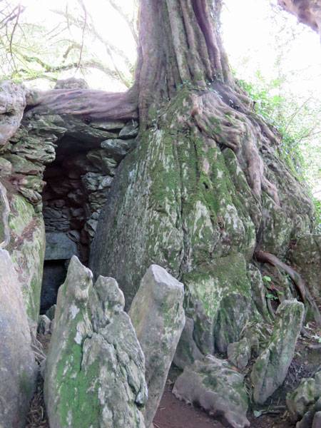
Druid’s Cave Said to once be the home of a religious hermit who was fed and cared for by the Jefferyes family… it may well have sheltered many others through the centuries.
entrance to Druid’s Cave
inside of Druid’s Cave
window at the back of Druid’s Cave
looking at the window (looks like a black hole near the bottom of the picture) from the outside of Druid’s Cave
The roots of the trees, I think most of them were Yews, were growing around the stones, and their branches made huge canopies over the rock formations.
2.5.18 ~ Rock Close, Blarney Castle, Blarney, Cork, Ireland
2.5.18 ~ Rock Close, Blarney Castle, Blarney, Cork, Ireland
2.5.18 ~ Rock Close, Blarney Castle, Blarney, Cork, Ireland
2.5.18 ~ Rock Close, Blarney Castle, Blarney, Cork, Ireland
2.5.18 ~ Rock Close, Blarney Castle, Blarney, Cork, Ireland
2.5.18 ~ Rock Close, Blarney Castle, Blarney, Cork, Ireland
Wishing Steps
looking down the Wishing Steps
For hundreds of years, the Blarney Witch has taken firewood from our Estate for her kitchen. In return, she must grant our visitors wishes.
at the bottom of the Wishing Steps
If you can walk down and back up these steps with your eyes closed — some suggest walking backwards — and without for one moment thinking of anything other than a wish, then that wish will come true within a year.
looking left from the exit of the Wishing Steps
We say only that the steps can be slippery and that we take no responsibility…
cannot remember what this was…
Witch’s Kitchen
Witch’s Kitchen
Historians will tell you that this was home to the very first Irish cave dwellers.
Witch’s Kitchen
But if you arrive early enough in the morning, you may still see the dying embers of a fire.
Witch’s Kitchen
Firewood, paid for by your wishes on the Wishing Steps, is lit every night by the Witch of Blarney, as she fights to stop shivering on her nocturnal escape from the Witch Stone.
Witch’s Kitchen
another leprechaun bridge!
another friendly robin
Witch Stone It takes little imagination to see who is imprisoned here. The Witch of Blarney has been with us since the dawn of time. Some say it was she who first told the MacCarthy of the power of the Blarney Stone. Fortunately for visitors, she only escapes the witch stone after nightfall — and we close at dusk.
2.5.18 ~ Rock Close, Blarney Castle, Blarney, Cork, Ireland ~ Witch Stone
Fairy Glade
2.5.18 ~ Rock Close, Blarney Castle, Blarney, Cork, Ireland
The faerie folk of Ireland are famed the world over for their mischief and charm.
2.5.18 ~ Rock Close, Blarney Castle, Blarney, Cork, Ireland
They have of course been here longer than any of us and it is our duty to keep them safe in this special glade.
2.5.18 ~ Rock Close, Blarney Castle, Blarney, Cork, Ireland
They do, however, have a native cunning.
we just missed seeing the fairy who darted inside and firmly closed the door
So if you spot one, don’t let it be fooling you.
more tempting paths to follow
There is so much to see at Blarney Castle & Gardens! Of the 14 things we could have seen here at Rock Close we saw only 5 of them. Elsewhere on the castle grounds there are more gardens, arboretums, woodland and riverside walks, the Blarney House… I could go on. There’s no way to see all this in a single day. I do hope I get to return here some day.
so many majestic trees…
On our way out something else caught our interest:
Where Two Rivers Cross
Prior to 1870, the River Blarney joined the River Martin near the Rock Close, but the course of the river was altered and the gradient was changed to increase the outflow of water when Inchancumain Bog was drained. The River Blarney was re-directed under the River Martin, which was channelled overhead via a short aqueduct.
where two rivers cross
At the point where the River Blarney emerges can be seen the remains of an old flax mill. It is a rare occurrence really in that one does not often find a place where one river passes under another. As a matter of interest, the River Martin was known as the River Aumartin in the 1600’s while the River Blarney was known as the River Whey.
Larisa picked us up and we headed back to her home. My cold by now had reached the runny nose phase and I went to bed early. Later that night Tim’s brother Josh arrived from England to visit with us for a few days. But this is the end of my photos.
The next day we went into Cork’s city center and spent the day shopping and visiting different pubs. It’s all a blur to me now because I left my camera at home and spent the day blowing my nose and feeling miserable. But I did manage to find some connemara marble for my sister!
And the day after that I stayed in bed while the others went to the Titanic Experience Cobh and saw Josh off at the airport later that day. That night Tim & I spent our last delightful evening with Katherine and her wonderful au pair, Anna, while Dima & Larisa went out on a date.
We arrived home on a Thursday and flew down to Georgia on Friday. Not pleasant flying so much with a clogged head! As it turned out Shannon had a sinus infection so we sat around talking ~ misery loves company. Tim and Nate were puttering around tending to techie projects and bringing us food. One afternoon we got ourselves out to a flea market and then a nice dinner out. And it was good seeing Julius and Dominic again ~ I cannot believe how much they have grown!
We flew home on Tuesday and I had my final radiation treatment on Wednesday. Phew! That was quite a vacation!
Today old man winter came back for a morning visit and left us 4 more inches of snow. A perfect day to snuggle in and finally finish these posts about our trips to Ireland and Georgia.
2.5.18 ~ Blarney Castle, Blarney, Cork, Ireland our first glimpse of the famous castle
Waking up Monday morning my cold wasn’t too bad, mainly a sore throat. Katherine had to go to school and her parents had to work so Larisa dropped us off at Blarney Castle. It was another damp and chilly day but we had fun.
The usual path to the castle was blocked off because they are in the middle of some major renovations.
another glimpse ~ we were definitely taking the long way around!
2.5.18 ~ Blarney Castle, Blarney, Cork, Ireland
When we got close to the castle we stopped and had the most delicious and warm bowl of Irish Stew at the Coach House Cafe. It really hit the spot. In spite of my sensitivity to wheat I took a bite of the warm brown bread that came with the stew. Yummy! 🙂 It’s not often one finds something that tastes so good at a cafeteria!
seating for summer tourists and an orb
The cafe was in the old stables and we ate in the main room. As we were leaving we saw that in the summer there was space right in the stalls for overflow dining. My only complaint was (again) no heat in the restrooms! Brrrr….
another building in the stable yard
looking though the book on Irish birds I bought at the wildlife park, I think this bird might be a pied wagtail ~ he was surveying the stable yard
the best shot I could get of the impossibly narrow steps
Because of the castle renovations we could not take the usual stairway up to the Blarney Stone. We never made it to the stone at the top because, well, the alternate steps were very small and continued to narrow the higher we went. We made it about 3/4 of the way up before we called it quits and retreated. We had to return home without our gift of eloquence. Notice in the picture above that the only railing we had was that wobbly rope. I’m only 5 feet tall and I had to duck to go through that doorway. And going down was even harder to pull off for these senior citizens. Phew!
2.4.18 ~ Killarney National Park Killarney, Kerry, Ireland
Our last stop for the day was at Killarney National Park where we walked a trail leading to Torc Waterfall. The forest we walked through was enchanting and wild. Unfortunately, it was here that I first felt an ominous scratch in my throat. But I was able to enjoy the hike and push away that nagging feeling that I was going to be in for it, a least for a couple more hours…
2.4.18 ~ Killarney National Park, Killarney, Kerry, Ireland
2.4.18 ~ Killarney National Park, Killarney, Kerry, Ireland
if it was this green in February imagine how much greener it will be in June
2.4.18 ~ Killarney National Park, Killarney, Kerry, Ireland
who might be in there?
2.4.18 ~ Killarney National Park, Killarney, Kerry, Ireland
2.4.18 ~ Killarney National Park
2.4.18 ~ Killarney National Park, Killarney, Kerry, Ireland
looks like a leprechaun bridge to me
2.4.18 ~ Killarney National Park, Killarney, Kerry, Ireland
2.4.18 ~ Killarney National Park, Killarney, Kerry, Ireland
my loved ones
2.4.18 ~ Killarney National Park, Killarney, Kerry, Ireland
2.4.18 ~ Killarney National Park, Killarney, Kerry, Ireland
perhaps someone’s first and last initial but the first thing we thought of was Barbara & Tim
my guy
2.4.18 ~ Killarney National Park, Killarney, Kerry, Ireland
2.4.18 ~ Killarney National Park, Killarney, Kerry, Ireland
2.4.18 ~ Killarney National Park, Killarney, Kerry, Ireland
Tim & Barbara at Torc Waterfall
Larisa and Barbara at Torc Waterfall
2.4.18 ~ Killarney National Park, Killarney, Kerry, Ireland
2.4.18 ~ Killarney National Park, Killarney, Kerry, Ireland
my girls ♡ (and the pink spoon)
I think I love the woods as much as the sea. It was a wonderful day!
2.4.18 ~ Caher Conor, Mount Eagle, Kerry, Ireland not sure if the 2,000 BC date is accurate ~ other sources suggest the 12th century
Sunday happened to be Imbolc, Groundhog Day, Candlemas or Brigid’s Day, about halfway between the winter solstice and the spring equinox. It marks the beginning of spring, which I now see comes a lot sooner in Ireland than it does in New England. Our first stop was at these fascinating beehive huts.
the canine proprietor greeting us was eager to sell us tickets
the ticket booth was a bit run down but Larisa found him friendly enough
Dima, Katherine and Tim had already started the 2-minute walk up the mountain path
the path narrows
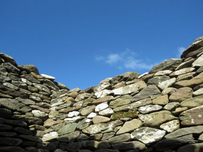
stone wall path boundary
2.4.18 ~ Caher Conor, Mount Eagle, Kerry, Ireland looking back down at the sea behind us
I loved the lichens on the stones and the little green mosses and plants
2.4.18 ~ Caher Conor, Mount Eagle, Kerry, Ireland
Also known as the Fahan Beehive Huts, Caher Conor (Cathair na gConchuireach) is located on the south side of Mount Eagle west of Dingle. The complex consists of five structures.
The clochan (beehive huts) in Caher Conor were probably single family dwellings and were attached to each other with a doorway leading from one to the other. They were built in the form of a circle of successive strata of stone, each stratum lying a little closer to the center than the one beneath and so on up to a small aperture at the top that could be closed with a single small flagstone or capstone. No mortar was used in building, which is called corbelling.
The hillside at one time had over 400 of these drystone, corbelled huts surviving, prompting one antiquarian in the 19th century to refer to the area as the “City of Fahan”. Dating the huts is difficult because the skill of corbelling has been used in Newgrange (3100 B.C.) and as recently as the 1950s. The huts at Fahan along the Slea Head Drive may well date to the 12th Century when the incoming Normans forced the Irish off the good land and out to the periphery of the Dingle Peninsula.
2.4.18 ~ Caher Conor, Mount Eagle, Kerry, Ireland orbs ~ I found the one with the bright center very interesting
it was so cold that Katherine finally relented and put her coat on ~ notice the pink plastic spoon in her hand ~ it was with her most of the day
Larisa and a gorgeous view
Dima and another view
this cross would make more sense being here if the wall was built in the 12th century
2.4.18 ~ Caher Conor, Mount Eagle, Kerry, Ireland
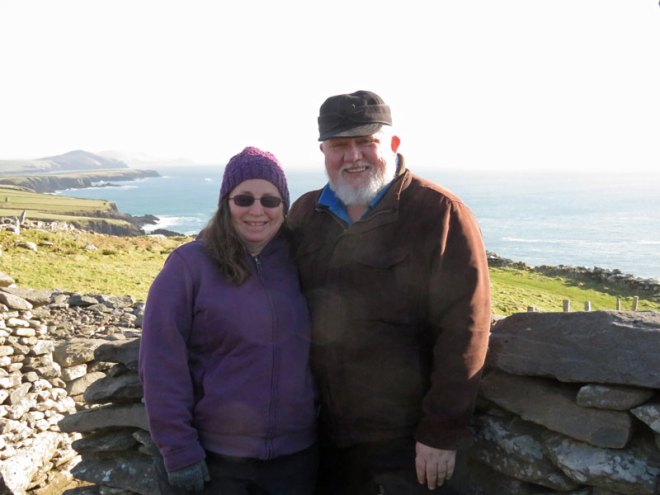
Barbara & Tim with orbs ~ Larisa knit the hat from Irish wool ~ at first she let me borrow it but then she gave it to me ~ now I have wool hats from Ireland and Norway!
I think Ireland may have even more stones than New England does!
2.4.18 ~ view from Caher Conor, Mount Eagle, Kerry, Ireland
coming around a corner
the walk back down to the parking lot
2.4.18 ~ Caher Conor, Mount Eagle, Kerry, Ireland
2.4.18 ~ Caher Conor, Mount Eagle, Kerry, Ireland
2.4.18 ~ Caher Conor, Mount Eagle, Kerry, Ireland
the canine proprietor keeping tabs on our departure
a door on a nearby building
the side of the same building, set well into the steep mountainside
the narrow, one-lane road between the entrance and the tiny parking lot
2.4.18 ~ Caher Conor, Mount Eagle, Kerry, Ireland view looking down from the parking lot ~ yikes!
It was good to get warmed up in the car and drive off for our next destination.